Size evaluation for the upperyard/upper half of Jaya

Avatar image for eazy_pezy
Eazy_Pezy

1598

Forum Posts

0

Wiki Points

0

Followers

Reviews: 0

User Lists: 0

#1  Edited By Eazy_Pezy

STEP 1:

I'll start by using Luffy running southbound at full speed along the coastline of Jaya(lower half/mouthpiece) from Mont Blanc Crickets house to Mocktown and back to ultimately find the size of the Lower half/Mouthpiece of Jaya which we will then use to find the size of the Upperyard/Top half of Jaya.

No Caption Provided

"Distance=Speed×Time" so to begin I'm going to need to outline the speed Luffy ran and the timeframe.

Speed

For this I could just use the speed of an athlete and be done with it but it would be pretty disingenuous to Luffy who is already operating at superhuman levels of speed and strength at the earliest arcs so instead I'll be using a statement from the Kuro arc to obtain a travel speed for Luffy.

Luffy says it would take him 20 seconds to cover the same distance it would take Ussop 3 minutes to cover.

With assumed athlete level speed for Ussop(no one in his village could catch him while he was sprinting so it's a safe assumption) which is 6.7m/s, I got Luffy's travel speed to 60.3m/s.

You can as well say that Luffy is throwing a random number into the air but there is no reason to believe so given the direness of the situation they were facing at the time(plus he manages to tag Kuro who could move FTE so his travel speed wouldn't scale that far off anyways) but if you're still indecisive about it you can assume a slightly higher speed value than 6.7m/s for Luffy since bare minimum those scans would translate to Luffy being faster than Ussop and it's not like he isn't to begin with.

Timeframe

Nami gives Luffy an ultimatum of 3 hours to go to Mocktown, defeat Bellamy, retrieve the gold stolen from Cricket and return back to which Luffy returns 46 minutes later than the intended time so the total time taken is 3 hours and 46 minutes(note: Nami does not state it takes 3 hours to make the journey but is the time Luffy had to do what he needed to do and return).

Now we can remove 46 minutes from the total timeframe to account for the time it takes for him to fight Bellamy, get the gold and find a stag bettle(a minor gag that was suppose to make light of Luffy coming late). Removing that amount time is more than generous as if you would read chapters 232 and 233 of OP, you would see for yourself that Luffy's ordeal with Bellamy and his crew takes 5-10 mins at most.

So after subtracting that time, the final timeframe(or the timeframe to run to and from Mocktown and Cricket's house respectively) is 3 hours. You can remove an additional 1 or 2 hours if you please but that would likely reduce the very end result to mid-high 2 digit kilometers or island sized.

STEP 2:

Now that I have both speed(60.3m/s) and time(3 hours or 10,800 seconds), I got 651.2km as the distance Luffy covered going to and from. To get the singular distance, I divide 651.2km by 2 which is 325.6km.

Using a nifty geometry software I was able to do this:

No Caption Provided

So to get the diameter of that circle/diameter of the island/size(width) of the island, I use the distance between Cricket's house and Mocktown like an arc on a circle and with a geometry software, I was able to get the angle of that arc to be 206° meaning the opposite angle is 154°. And so:

206°=325.6km(Length of arc DE)

154°=Unknown(Length of arc ED)

Using direct proportions, Unknown=243.4km

Now to find the radius which will ultimately lead to finding the diameter, we have to get the circumference:

So Circumference(C)=Length of arc DE+Length of arc ED=325.6km+243.4km=569km

r(radius)=(C/2.pie)=569/(2×3.142)=90.56km

D(Diameter)=2r=2×90.56=181.12km.

So we have that the length of the mouth part of the skull shaped Island Jaya is 181.12km. Comparing it to it's top half or the upperyard, it's visibly smaller.

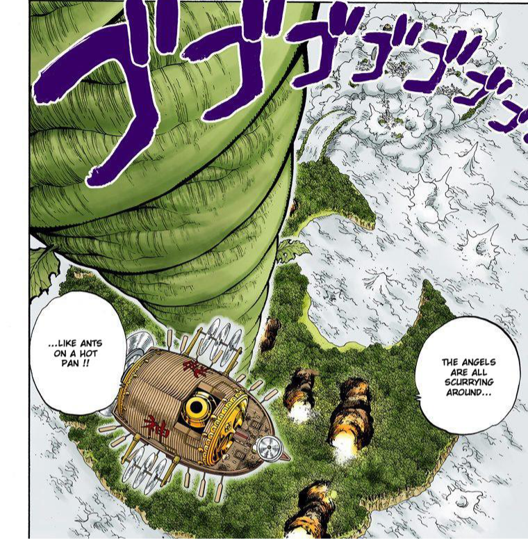
No Caption Provided

Just by looking I can estimate that the upperyard is at least 200km wide(Using pixel scaling I got it to be 253.52km). For reference, Israel which is a small country is about 205km.

So what are your thoughts on this?

Avatar image for oreoghoul
Oreoghoul

3641

Forum Posts

0

Wiki Points

0

Followers

Reviews: 0

User Lists: 0

@eazy_pezy: interesting. How big would you say Skypiea is with this in mind?

Avatar image for wushu59
Wushu59

13874

Forum Posts

150

Wiki Points

0

Followers

Reviews: 0

User Lists: 8

#3  Edited By Wushu59

Cool post.

I wonder Eiichiro Oda creates his geography with particular size in mind.

It wouldn't surprise me. He is known to use codes and numbers to foreshadow.

Avatar image for eazy_pezy
Eazy_Pezy

1598

Forum Posts

0

Wiki Points

0

Followers

Reviews: 0

User Lists: 0

#4  Edited By Eazy_Pezy
@oreoghoul said:

@eazy_pezy: interesting. How big would you say Skypiea is with this in mind?

If you're talking about this:

No Caption Provided

It's 200km at least and that's about the size of a small country. Should be somewhere at the bottom of my post

Avatar image for oreoghoul
Oreoghoul

3641

Forum Posts

0

Wiki Points

0

Followers

Reviews: 0

User Lists: 0

Avatar image for eazy_pezy
Eazy_Pezy

1598

Forum Posts

0

Wiki Points

0

Followers

Reviews: 0

User Lists: 0

@eazy_pezy: ooo right my bad!

Perfectly fine dude. I remember you mentioning how you're just getting into OP

Avatar image for yray
Yray

4240

Forum Posts

0

Wiki Points

0

Followers

Reviews: 0

User Lists: 0

Nicely done bro 👏👌

Avatar image for shirso
shirso

15066

Forum Posts

0

Wiki Points

0

Followers

Reviews: 0

User Lists: 0

Bro it's larger than 200 km if Jaya alone is about 180 km diameter. Eyeballing, Skypiea should have about 400-450 km diameter.

Avatar image for eazy_pezy
Eazy_Pezy

1598

Forum Posts

0

Wiki Points

0

Followers

Reviews: 0

User Lists: 0

@shirso said:

Bro it's larger than 200 km if Jaya alone is about 180 km diameter. Eyeballing, Skypiea should have about 400-450 km diameter.

It's at least 200km by eyeballing for me so you could probably have a far higher value depending on how you look at it. But with pixel scaling I got 253.52km.

Avatar image for deactivated-63e4c52ea7a93
deactivated-63e4c52ea7a93

1890

Forum Posts

0

Wiki Points

0

Followers

Reviews: 0

User Lists: 0

Israel's full view landmass from space altitude:

No Caption Provided

Full view of Skypia from altitudes well below the picture above:

No Caption Provided

Really got excited for country level Enel, huh, Eazy?

No Caption Provided

Avatar image for shirso
shirso

15066

Forum Posts

0

Wiki Points

0

Followers

Reviews: 0

User Lists: 0

#11  Edited By shirso

If that's Cyprus to the left then that's not just Israel, but showing a Cyprus, a large chunk of Turkey, the Meditternanean Sea and Jordan, the Persian gulf to the right of Israel.

Not sure what this is supposed to even prove, that satellite scan shows a lot lot more than Israel so your argument is already faulty. And unlike the Skypiea scan, this ain't a near perfect top down perspective.

Come on Woody, you are better than this, no need to lowball obviously explicit facts.

Avatar image for eazy_pezy
Eazy_Pezy

1598

Forum Posts

0

Wiki Points

0

Followers

Reviews: 0

User Lists: 0

#12  Edited By Eazy_Pezy

@molt: Molt...the image of whatever country you posted there(props for shitty image) is heavily distorted because camera lenses(or lenses in general) distort light. What you think(I hope you do at all) is a curvature there is a distortion caused by the lense of the camera that took the photo. Now let's assume in this fantasy land of yours where you think you're the smug smart guy(far from in reality) that the image of the country you posted has a true curvature, wouldn't comparing a scan that shows a direct birdeye view of an island and an image showing the birdeye view of a country at an angle be devoid of reasoning? Besides the OP planet is far larger than our own having islands like Alabasta(which is the size of continent) on the grandline be a mere speck compared to actual continents of the planet like the red line.

Avatar image for eazy_pezy
Eazy_Pezy

1598

Forum Posts

0

Wiki Points

0

Followers

Reviews: 0

User Lists: 0

Bump

Avatar image for alextheboss
alextheboss

30411

Forum Posts

0

Wiki Points

0

Followers

Reviews: 0

User Lists: 0

#14 alextheboss  Online

@eazy_pezy: No, there is still planet curvature from that type of distance, the camera is distortion is just adding to it/making it look weird.

However you could just argue Oda messed up the visuals, similarly to how Bleach messes up the visual size of the seiretei. I'm not going to get into if visuals trump statements or calcs, but by visuals sky island clearly isn't even close to country size. You can literally see the sides of the trees and the buildings down below, lol.

Avatar image for eazy_pezy
Eazy_Pezy

1598

Forum Posts

0

Wiki Points

0

Followers

Reviews: 0

User Lists: 0

#15  Edited By Eazy_Pezy

@alextheboss:

No, there is still planet curvature from that type of distance, the camera is distortion is just adding to it/making it look weird.

No I'm not saying there wouldn't be a curvature there at all just that the camera would distort it to look more curved than it actually is. Same thing you're saying here.

However you could just argue Oda messed up the visuals, similarly to how Bleach messes up the visual size of the seiretei. I'm not going to get into if visuals trump statements or calcs, but by visuals sky island clearly isn't even close to country size. You can literally see the sides of the trees and the buildings down below, lol.

Another case of bad visuals really. I'll check later but near the beginning of the mini arc we see the crew taking some hours to sail between the two peaks of modern day Jaya and also Bellamy's crew setting out to rob Cricket at high noon but arriving at eventide.

Avatar image for deactivated-63055b33107d2
deactivated-63055b33107d2

1764

Forum Posts

0

Wiki Points

0

Followers

Reviews: 0

User Lists: 0

They refer to Skypeia as a Country multiple times in the manga

Avatar image for deactivated-63056cb90ac15
deactivated-63056cb90ac15

1129

Forum Posts

0

Wiki Points

0

Followers

Reviews: 0

User Lists: 0

Whitebeard can easily bust Skypeia with the Gura Gura no Mi

Avatar image for eazy_pezy
Eazy_Pezy

1598

Forum Posts

0

Wiki Points

0

Followers

Reviews: 0

User Lists: 0

Bump

Avatar image for dbzfan44_alt
DbzFan44_ALT

1607

Forum Posts

0

Wiki Points

0

Followers

Reviews: 0

User Lists: 0

@molt said:

Israel's full view landmass from space altitude:

No Caption Provided

Full view of Skypia from altitudes well below the picture above:

No Caption Provided

Really got excited for country level Enel, huh, Eazy?

No Caption Provided

exactly.

One Piece wankers will never accept that the verse is below hawaii level.

Avatar image for dbzfan44_alt
DbzFan44_ALT

1607

Forum Posts

0

Wiki Points

0

Followers

Reviews: 0

User Lists: 0

@molt: Molt...the image of whatever country you posted there(props for shitty image) is heavily distorted because camera lenses(or lenses in general) distort light. What you think(I hope you do at all) is a curvature there is a distortion caused by the lense of the camera that took the photo. Now let's assume in this fantasy land of yours where you think you're the smug smart guy(far from in reality) that the image of the country you posted has a true curvature, wouldn't comparing a scan that shows a direct birdeye view of an island and an image showing the birdeye view of a country at an angle be devoid of reasoning? Besides the OP planet is far larger than our own having islands like Alabasta(which is the size of continent) on the grandline be a mere speck compared to actual continents of the planet like the red line.

trees in skypiea can be seen from that distance yet the mountains in israel can't be seen.

Mountains>>>>trees.

Israel>>>>>skypiea.

The height the image of Israel is taken is far above fodderpiea.

Cope.

Below hawaii level.

Avatar image for jieldre
Jieldre

1833

Forum Posts

0

Wiki Points

0

Followers

Reviews: 0

User Lists: 0

Lmaoooo

Avatar image for eazy_pezy
Eazy_Pezy

1598

Forum Posts

0

Wiki Points

0

Followers

Reviews: 0

User Lists: 0

@dbzfan44_alt: poorly scaled visuals(for more read the my replies). Even after all this time spent off the site you still couldn't acquire working brain cells...

Anyways don't expect a reply unless you would like to bring up something I haven't touched yet.

Avatar image for dbzfan44_alt
DbzFan44_ALT

1607

Forum Posts

0

Wiki Points

0

Followers

Reviews: 0

User Lists: 0

@eazy_pezy: How is a poorly scaled? How is ad homin gonna help?

Avatar image for eazy_pezy
Eazy_Pezy

1598

Forum Posts

0

Wiki Points

0

Followers

Reviews: 0

User Lists: 0

Avatar image for dbzfan44_alt
DbzFan44_ALT

1607

Forum Posts

0

Wiki Points

0

Followers

Reviews: 0

User Lists: 0

#27  Edited By DbzFan44_ALT
@eazy_pezy said:

@dbzfan44_alt: "for more read the my replies"

I saw nothing that proves how an island which its trees and its entirety can be seen from above is close to Israel with whom mountains can't even be seen when seeing all of Israel.

The only way to claim its bad visuals if its you somehow believe trees are above mountains.

Avatar image for eazy_pezy
Eazy_Pezy

1598

Forum Posts

0

Wiki Points

0

Followers

Reviews: 0

User Lists: 0

@eazy_pezy said:

@dbzfan44_alt: "for more read the my replies"

I saw nothing that proves how an island which its trees and its entirety can be seen from above is close to Israel with whom mountains can't even be seen when seeing all of Israel.

Bad visuals.

The only way to claim its bad visuals if its you somehow believe trees are above mountains.

If you bothered to read the thread properly you would see where I mention other evidences for the island being larger than depicted.

Avatar image for dbzfan44_alt
DbzFan44_ALT

1607

Forum Posts

0

Wiki Points

0

Followers

Reviews: 0

User Lists: 0

@dbzfan44_alt said:
@eazy_pezy said:

@dbzfan44_alt: "for more read the my replies"

I saw nothing that proves how an island which its trees and its entirety can be seen from above is close to Israel with whom mountains can't even be seen when seeing all of Israel.

Bad visuals.

The only way to claim its bad visuals if its you somehow believe trees are above mountains.

If you bothered to read the thread properly you would see where I mention other evidences for the island being larger than depicted.

you haven't shown evidence for skypiea.

Avatar image for eazy_pezy
Eazy_Pezy

1598

Forum Posts

0

Wiki Points

0

Followers

Reviews: 0

User Lists: 0

@dbzfan44_alt: "near the beginning of the mini arc we see the crew taking some hours to sail between the two peaks of modern day Jaya and also Bellamy's crew setting out to rob Cricket at high noon but arriving at eventide."

You're mentally draining.

Avatar image for dbzfan44_alt
DbzFan44_ALT

1607

Forum Posts

0

Wiki Points

0

Followers

Reviews: 0

User Lists: 0

@dbzfan44_alt: "near the beginning of the mini arc we see the crew taking some hours to sail between the two peaks of modern day Jaya and also Bellamy's crew setting out to rob Cricket at high noon but arriving at eventide."

You're mentally draining.

more ad homin?

those must be some slow ships if they take hours to sail an island where trees can be seen from it.

Is there any proof Luffy was running the whole time to get to bellamy?

Avatar image for dbzfan44_alt
DbzFan44_ALT

1607

Forum Posts

0

Wiki Points

0

Followers

Reviews: 0

User Lists: 0

Avatar image for eazy_pezy
Eazy_Pezy

1598

Forum Posts

0

Wiki Points

0

Followers

Reviews: 0

User Lists: 0

#33  Edited By Eazy_Pezy

@dbzfan44_alt more ad homin?

those must be some slow ships if they take hours to sail an island where trees can be seen from it.

Average speed of a pirate ship is 18km/h(takes those ships multiple hours to sale around the island)

Is there any proof Luffy was running the whole time to get to bellamy?

Nah he was just strolling to Mocktown after Nami told him he had a limited amount of time to settle the dispute~obvious sarcasm~...it's very clear you haven't read the arc(probably even OP as a whole).

Sure does look like Luffy is walking in this scan...
Avatar image for eazy_pezy
Eazy_Pezy

1598

Forum Posts

0

Wiki Points

0

Followers

Reviews: 0

User Lists: 0

Brodie pulled up with an anime opening video to make an argument...I should know better than to entertain time wasters .

Avatar image for dbzfan44_alt
DbzFan44_ALT

1607

Forum Posts

0

Wiki Points

0

Followers

Reviews: 0

User Lists: 0

@dbzfan44_alt more ad homin?

those must be some slow ships if they take hours to sail an island where trees can be seen from it.

Average speed of a pirate ship is 18km/h(takes those ships multiple hours to sale around the island)

Is there any proof Luffy was running the whole time to get to bellamy?

Nah he was just strolling to Mocktown after Nami told him he had a limited amount of time to settle the dispute...it's very clear you haven't read the arc(probably even OP as a whole).

Sure does look like Luffy is walking in this scan...

Nah he was just strolling to Mocktown after Nami told him he had a limited amount of time to settle the dispute...it's very clear you haven't read the arc(probably even OP as a whole).

I see.

Why is Luffy's running speed consistently the same as everyone elses though. For instance there is the intro, or how in impel down his speed was about the same as fodders like Buggys, marineford war, etc.

Avatar image for dbzfan44_alt
DbzFan44_ALT

1607

Forum Posts

0

Wiki Points

0

Followers

Reviews: 0

User Lists: 0

#36  Edited By DbzFan44_ALT

@eazy_pezy: anyways I won't take this calculation as valid unless I see Luffy's running speed being consistently above everyone elses instead of literally just one scan.

Avatar image for pr03
Pr03

2705

Forum Posts

0

Wiki Points

0

Followers

Reviews: 0

User Lists: 0

That's some next level analysis.

Avatar image for eazy_pezy
Eazy_Pezy

1598

Forum Posts

0

Wiki Points

0

Followers

Reviews: 0

User Lists: 0

Bump